

Serendipity Beneath Satellites
Serendipity Beneath Satellites
Is Google Maps a good travel companion?
Welcome to Issue 2, where we reflect on navigation in the age of Google Maps. Having a smartphone with access to most of the world’s knowledge and a constant connection to GPS has been a game changer for travel, inspiring trips to new corners of the world and providing safety even in remote locales. But it can also make us more distracted from our journey and less confident in our wandering. Is mapmaking a necessary experience in our formation of place? Though most of us are staying close to home these days, perhaps it will be something to think about even when walking well-worn routes. Thanks for reading. We hope you’re staying safe and healthy wherever you are. As always, send us any passing thoughts at placeletter@protonmail.com - The Place editorial team

Google Street View: Oudayas, January 2019. Photo: Darem Bouchentouf
The Blue Dot
Time can distort distances and directions once known intimately, like wood warping from seasons of rain and sun. But the second I stepped off the air-conditioned airport bus into the warm evening air last December, I remembered the route from the Rabat Ville station to the medina, even eight years after leaving Morocco.
The bus stopped directly outside the entrance to a friend’s old apartment, where we used to drink coffee and swap stories on her sunny balcony overlooking the stately Avenue Mohammed V. Instinctively I turned left, darting across the tram tracks without waiting for the traffic light, beginning a brisk walk to my destination. Nostalgia, however, soon slowed me to a stroll.
The landmarks of Rabat were where I remembered them, but not as I remembered them. There was the spot where I tripped over a tree root on the center promenade while interviewing activists protesting budget cuts. Now it was only populated by pigeons. The leafy veranda of Hotel Balima, where Rabat’s intellectuals sat for hours sipping café nus nus and chatting between drags of cigarettes, was now under renovation, the rows of street-facing wicker chairs hidden by a temporary plywood wall. Further down the boulevard I discovered that Le Grand Comptoir, an ornate bistro where we began a raucous night of Halloween festivities, had been replaced by a tapas bar, the new logo unceremoniously stuck over the old gold scripted sign.
As I reconciled my old memories with the new Rabat, my feet didn’t hesitate. My sense of direction, built from walking down this street dozens of times as a student, didn’t falter. Still, I couldn’t shake the navigational habits I had formed in my years away. I had my phone in my right hand with Google Maps open, surreptitiously checking my route as I walked. The blue dot confirmed my location, pinging my data to a satellite thousands of miles above, following along as I walked down memory lane.
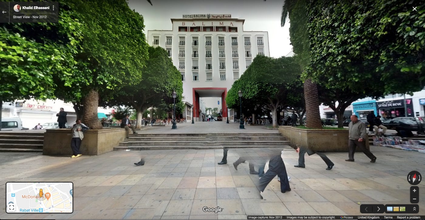
Google Street View: Hotel Balima, November 2012. Photo: Khalid Elhassani
When I first stepped out of Rabat Ville train station in September back in 2012, I had no data, no wifi, and essentially no idea where I was.
I had arrived with a friend with whom I’d be studying abroad, both of us deciding to fly first to Casablanca and then take the train to Rabat to save money. We had the name and address of a hotel where we were supposed to meet our program, but the area looked different — real life hardly ever looks like the birds-eye view of Google maps.
At the time, international data and calling plans were expensive and cumbersome to sign up for. WiFi was only available in a handful of cafes. Google Street View hadn’t yet been mapped in Morocco. We were at the mercy of our intuition and Rabat’s locals.
We chose a direction and trudged along the cement sidewalks in the 30 degree summer heat, my massive blue backpack hunched over my increasingly sweaty shoulders and my rolling suitcase getting caught on curbs. We wandered along side streets with no clearly visible post addresses or street signs, getting different directions in French, Arabic, Spanish and English from men in bright t-shirts and scuffed sandals. Finally, we stumbled upon the hotel, marked by a tiny hanging sign indicating a nondescript entrance. We lugged our suitcases up to the first floor reception, which was quieter than expected for being the meeting point of an entire study abroad program. The man at the counter looked at us in confusion. Who are you supposed to meet? he asked.
As it turns out, we didn’t even have our destination correct. In the hours without Internet connection, our program director had emailed to let us know that the hotel had changed. We used the reception landline to call him and minutes later we were in a taxi that took us a five minute drive down Avenue Mohammed V to the entrance of the medina, after an hour of being lost.
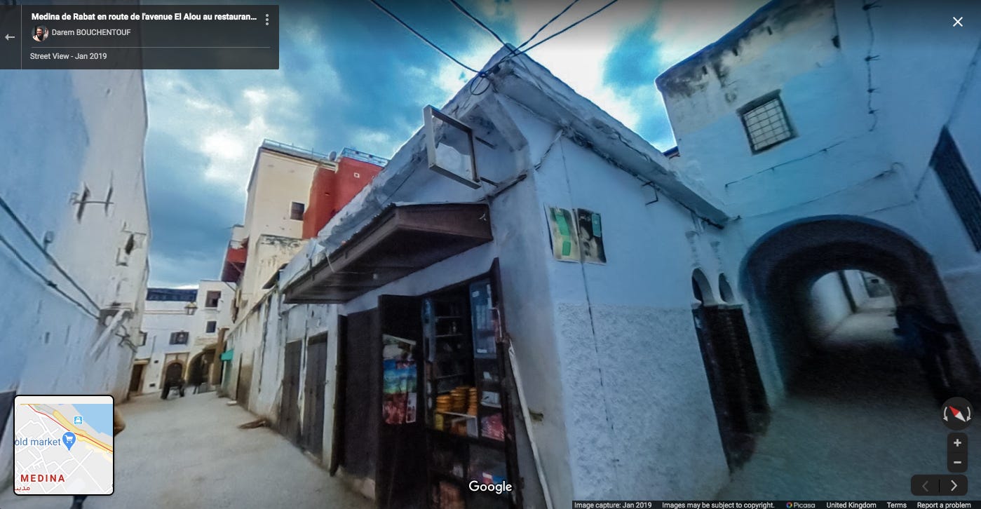
Google Street View: Medina de Rabat, January 2019. Photo: Darem Bouchentouf
In the weeks that followed, our initial lack of orientation in the city’s neat and tree-lined Centre Ville seemed ludicrous in the face of the navigational challenge that lay ahead. We stayed with host families who lived on the narrow streets of Rabat’s medina, a walled city dating back to the 12th century. The route from my school to my front door required nearly half a dozen turns, requiring me to remember that my street came after the stall with wooden carvings but before the stall that sold soap -- I was always relieved when I saw the blue shutters of the bakery at the end of my alley, piled high with khobz and saran-wrapped biscuits.
Smartphone penetration at the time in Morocco was just 16 percent and data was slow and unreliable. We all bought cheap plastic burner phones at the beginning of the semester, re-learning T9 word to text our host families if we’d be late for Friday cous cous. There was no blue dot to confirm my location. Ultimately, I had no choice but to remember my route or get lost in the maze.
At the time, I didn’t think much about satellite maps because the opportunity for discovery felt expansive. On one of the earlier days, I wandered through the massive wooden gates of what I later realized was the Kasbah of the Oudayas, the Andalusian-era quarter where the walls are painted in a fresh white and cerulean blue, pink bougainvillea tumbling from terraces. A few improvised turns later and I exited out to the fort walls overlooking the crashing waves of the Atlantic. I walked down another alley, stumbling upon a lush garden and a tiled café tucked into a cliffs overlooking the beach. Every turn felt like the right one, no matter which direction.
An internal sensor for when something felt off developed too. A street too quiet, a man following too close behind. I learned to keep my head up and my eyes alert for landmarks, navigational clues and the nearest old woman in a djellaba who would have my back if someone was being truly disrespectful. In Fez, I tried to approach the 1,100-year-old medina with the same pioneering spirit, but its mystery proved too great a match for my new skills. While walking with a friend off our well-trod route, we took a few turns before getting that spine-tingling feeling. A teenage boy took one look at us and gave us a warning wave – you shouldn’t be here, he said. We turned on our heels and retraced our steps.

Google Street View: Oudayas, January 2019. Photo: Darem Bouchentouf
I returned to Morocco this December, with a few more stamps in my passport and a lot more technology in my pocket. I have an iPhone and a phone carrier that automatically gives me at least 2G data in over 150 countries, Morocco included. While not enough to scroll Instagram, I’m almost always able to reliably locate myself on Google Maps. (Smartphone penetration in Morocco has now risen to over 73 percent).
In some ways, I believe that being able to know where I am at all times has made me a more confident traveler. As a solo traveler, being able to walk down whatever street I please and still find my way back to my hostel (barring battery life) is exhilarating. As a journalist always gathering string, dropping a pin and being able to reliably retrace my steps is fascinating. As a woman, for whom the wrong direction could be deadly, it’s been liberating. In completely unfamiliar cities and wilderness on the other side of the world, that sense of place has put me at ease. No matter how widely I’ve wandered the blue dot has been with me.
But it’s also made me lazy. Sometimes I barely map out a city before arriving, knowing I can Google directions on arrival. I save trendy coffee shops and historical landmarks to a Google Maps list before traveling somewhere, ignoring the fact that interesting places also exist off the Internet. I’ve had to remind myself that serendipity should be cultivated, not Googled.
Being back in Morocco with the aid of location data was gratifying, at first. Everything was much more efficient. Upon arrival in Rabat, I remembered the name of a restaurant I went to occasionally but wasn’t sure if I’d remember how to get there. I searched “Dar Naji” and a blue line appeared, guiding me around a curve in the medina wall I wouldn’t have recognized under scaffolding and past the stands selling the fragrant snail soup, babouche, which I’d forgotten about. Later that evening I felt at ease taking cat naps as my train trundled toward Marrakesh, keeping an eye that we were following the expected tracks illustrated on my screen rather than just hoping I’d be able to pick out my station announcement from the crackling loudspeaker.
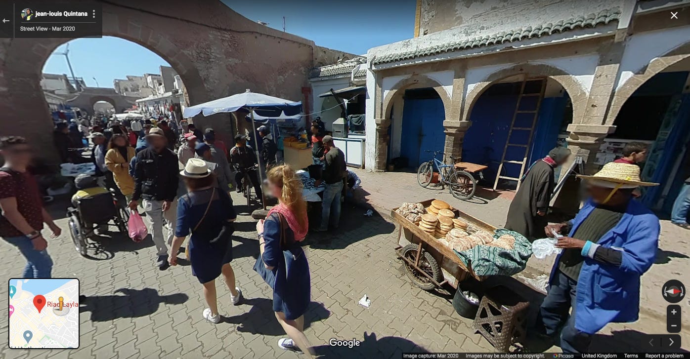
Google Street View: Medina d'Essaouira, March 2020. Photo: Jean-Louis Quintana
A few days later I confidently stepped into the Essaouira medina, shortening the zig zagging blue line on my Google Maps from the entrance to my riad with every step. It was like I had the answer key to the maze. While it was impossible to keep my eyes on my screen as I took in the scene around me -- a patchwork of rainbow colored slippers, Berber pharmacies advertising an all-natural viagra, a cat curled up in the center of coiled tubing -- I felt the blue dot nagging in my pocket. Had I walked too far? Was I meant to turn down that alley? I unlocked my phone, pressed the compass icon and was relieved to see I was still en route.
The blue dot was the most certain verification of my presence, and it was the one thing that distracted me from where I physically was.
In 2012, without having technology to rely on, I had to spend weeks developing my senses and recalibrating my gut feelings. This was deeply formative -- it taught me that I could rely on myself in unfamiliar places, the key that unlocked a gate to travel that I hadn’t known was holding me back. I wonder, if I had access then to the technology I do today, would I have missed the captivating allure of mapping somewhere new? Or would have I been even more adventurous, knowing that I was always found even when I forced myself to be lost?
I looked up from my phone. All around me thousands of tiny details tempted my curiosity: spindly sugarcane stalks sticking out of a juice stand, hanging rugs in bright Berber patterns, freshly caught silvery fish stacked on ice below a blue umbrella, a white minaret broadcasting the call to prayer above bustling streets. I didn’t want to miss these because I was focused only on my destination. I felt another wave of relief; my old instincts were still there, even as I used Google Maps.
So, I studied the route to my Essaouira riad one last time, memorizing my next few steps. Left after Patisserie La Bienvenue, turn after the third alleyway on the right, I recounted to myself. I locked my phone and zipped it in my pocket, quieting my digital companion for the time being. My brain took over as my compass. The satellites continued to orbit thousands of miles overhead, keeping a watchful eye on my journey.
Karis Hustad is a journalist based in London, UK. She’s covered tech, finance and politics from the US, India, Morocco, Denmark, Sweden, the UK and the Netherlands.
Place recommends:
A concert in the borderlands.
An essay from Belize.
A thread of beautiful rooms.
Bonus: Follow the route through the Rabat medina
Join us next week as Kylee looks for trees and finds relics in Ethiopia.